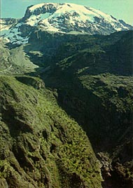
Kilimanjaro by the Machame Route
8 days Grade B/C Fully Porter Supported
Book Now | Prices on new EWP website
A popular route following steep paths through magnificent forests to gain a
ridge leading through the moorland zones to the Shira Plateau. It then
traverses beneath the glaciated precipices of the south face of Kibo providing
superb views of the Southern Icefields. An extra day could be added to the
itinerary, spent
either on the Shira Plateau, where you could walk to the Shira Needles, or
camping
in the Karanga Valley.The final ascent is made very early in the morning from the Barafu Hut.
The Mweka Route is used for the descent. Accommodation on the mountain is in tents; you will need a sleeping
bag and but a sleeping mat is provided. The porters will pitch the tent for you
but are welcome
help if you wish. This is a strenuous walking trip but within the limits of a fit individual
used to walking in mountain areas. Ski sticks or walking poles are useful when
ascending the scree to the summit. Programme- Arrive at the Springlands Hotel (B&B).
- Drive to Machame village. The climb begins at the end of the tarmac road.
Walk through shambas then forest to the Machame hut (3000m, about 6 hours).
- Continue along the steep ridge going on to rock ridges and through heather.
The route turns west into a river gorge, reaching Shira hut at 3800m, 5
hours.
- Continue east towards Kibo passing the junction, then east towards the
Lava Tower. Shortly after this, you descend to Barranco hut (3940m, 4 hours).
- A short scramble to the top of the Great Barranco and then a traverse over
scree and ridges to the Karanga Valley (4000m, 3 hours), beneath the icefalls
of the Heim, Kersten and Decken Glaciers. After climbing out of the Karanga
Valley the trail ascends a ridge to the Barafu Hut, a bleak location with
little vegetation at 4600m, (3 hours walking). Video
- An early start for the ascent to the rim of the Kibo Crater between the
Rebmann and Ratzel Glaciers, (4 hours); the last section before the rim
can sometimes be snow-covered and an ice-axe or ski stick is useful for
balance. From here a further hour leads to Uhuru Peak, from where there
are often fine views of Meru to the west and the jagged peak of Mawenzi
to the east. Descend to the Barafu Hut for a rest and lunch before continuing
on down to camp at Mweka Hut in the giant heather zone on the forest edge.
Those with energy on the summit may wish to descend to the Reutsh Crater
and visit the dramatic ice pinnacles of the Eastern Icefields. Video
- A 3-4 hour descent through beautiful forest brings you to the Park gate
and your waiting transport. Drive back to the hotel.
- Depart hotel after breakfast. Transfer to airport or continue on an extension.
Western Breach Variation: Umbwe Route then Uhuru Point by the Western Breach
This is a really steep, hard but short route to the summit from
Arrow Glacier Camp which is itself reached in about 4 hours from the Barranco
Hut. From December to February crampons and ice axes may be needed.
Some prefer to start from the slightly more comfortable but lower Lava Tower
camp - this adds just over an hour to the ascent. The programme is available all the year round. Included in the cost :
All park fees, guides, porters, cook, all meals on the mountain and breakfast at the hotel. Not included in the cost:
Tips, airport transfers, extra drinks and additional meals at the hotel. See also hotel details and facilities, safari extensions, Zanzibar extensions, weather. Book Now | Prices | Machame Picture Gallery |  Kilimanjaro from Barranco Kilimanjaro from Barranco
Descending the Mweka Route
Machame Picture Gallery |


