Kamchatka is known to Moscow schoolchildren as the back of the class. It is
Russia's most remote province, a peninsula 1200 kms long by 450 kms across, and
approximately the size of the U.K., which is bounded by the Pacific Ocean and
the Bering Sea in the east and the Sea of Okhotsk in the west.
It is a wild mountainous land, lying on the 'Pacific Rim of Fire', a highly
unstable geological area prone to volcanic eruptions and earthquakes,
stretching from Alaska in the east across the Aleutians to Kamchatka and
southwards to Japan. 
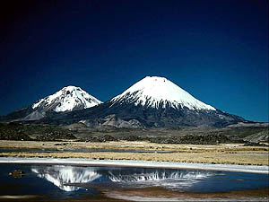
Koriakskaya from Avachynskaya Sopka "From the deserts of black ash left by recent eruptions springs a wealth of
plants and flowers - many unique to the peninsula - the rocky coastline is home
to an immense number of sea-birds, while inland, bears compete with smaller
mammals for the harvest of berries gleaned from bushes growing on the banks of
lakes of boiling mud. when the salmon teem into the rivers and vast volcanic
peaks loom over the landscape erratically erupting with dazzling displays of
fire, clouds of ash and stream of red-hot lava". These comments were made by Robert Perkins, the American ecologist when he
visited Kamchatka in 1990. He was possibly the first Westerner to have visited
Kamchatka in 40 years.
It is a remote region of Russia being 9 time zones from Moscow and until
recently sealed-off to foreigners and most Russians. The area was shrouded in
secrecy it being the home of the Soviet Pacific fleet.
Our trip passes through the wilderness areas of the volcanoes and hot springs
in two areas, one to the south and the other to the west of Kamchatka's main
town and port - Petropavlovsk. Access to the second part of the trek is easier
with shorter travelling time involved. Climate
A more extreme climate than the U.K. with snows and cold clear weather from
November through to April. The summers can be surprisingly warm - many, warm
days alternating with damp foggy conditions which drift in from the Pacific.
As the winter snows are slow to melt, July, August and September are the best
times for trekking although ski-touring is perfect in spring time. Late summer
and autumn bring the magnificent reds and yellows to the landscape and this is
the time the Kamchatkan bears are berry-picking and fishing for the Pacific
salmon which ascend the rivers in vast numbers. Health Matters and Documents
A visa is required for entry into Russia. This has to be applied for well in
advance since the normal turn around time to you for obtaining it takes
approximately 4 weeks. It can be obtained more quickly but this is often
expensive. If you are likely to need your passport 6 weeks prior to departure
please let us know to discuss alternative arrangements.
There are no compulsory vaccinations required for entry into the area but
please consult your doctor regarding travel to Kamchatka. In particular
mention encephalitis from tick bites. You will need a good insect repellent
against mosquitoes for their nuisance value although they are not malaria
carrying . Grade
Some long days and some steep ascents to the passes and crater rims. Our route
follows trails but they are not waymarked nor well trodden for the most part. Weather, clothes, equipment
The weather is not extreme at this time of year, day temperatures in the
mountains are approx. +20°C. Warm clothes are required for evening and
nights.
Full, lightweight, waterproofs required as some rain should be expected.
Waterproof, strong walking boots with good ankle support are essential but you
will also find waders are very useful when crossing streams and swampy terrain.
Light weight trousers are useful for the lush undergrowth through which the
route goes.
Walking poles can be very useful especially for river crossings and boulder
fields.
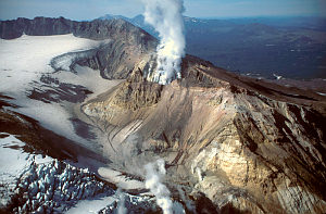
Mutnovsky from air
Koryaksky volcano near Petropavlovsk
| Kamchatka Grade
B/C
This is a partly porter-supported trek, full support available on request. 14
days ex-Petropavlovsk
For dates and prices see Dates and Prices 
waders are useful!Itinerary
We can arrange flights for you to Petropavlovsk either from London or from
Moscow. Please enquire for details.Day 1. Arrival in Petropavlovsk. Transfer to a hotel. Welcome dinner in a city restaurant.
Day 2. Drive by 6WD bus to the Gorely Volcano caldera at the base of Mutnovsky Volcano. This caldera is an otherworldly landscape of dry ash and scattered volcanic rocks from the many eruptions of Mutnovsky and Gorely Volcanos. Here base camp is made between the two volcanos. Take short walks up the encircling ridge lines to see the large mountain marmots that inhabit the area. See the Kamchatka rhododendrons and variety of other mountain flowers.
Day 3. Day trip to Mutnovsky volcano (2323m). The Mutnovsky Volcano's nest of merged craters is perhaps the most beautiful volcanic phenomenon of Kamchatka. The view from its top is a magnificent: steep walls surrounding the vast and deep crater cavity, glittering of firn and sparkling glaciers split by cracks, torches of fumaroles shimmering far below and drawing a translucent veil over the northern crater, the southern crater under its armour of ice and above all this a column of vapour rising from the surrounded by cogged crest Active Funnel crater (10km).
Day 4. Trek down to the Voinovskye hot springs (18km). Starting at the Mutnovsky Thermal Station on the North East side of Mutnovsky Volcano you will descend along an abandoned geologist's dirt road into the valley of the Mutnovskaya River. During the decent alpine vegetation is replaced with subalpine, and you pass the first bushes and trees. This section of the trek affords a spectacular view of the richly vegetated lowlands through which you'll be raveling in the coming days and magnificent scenery in the surrounding mountain cirques. Make camp on the banks of the Mutnovskaya River. Bath in the small, wild, Voinovskye hot springs which bubbles up in a sandbar with the river flowing all around.
Days 4 and 5 of this trek require several river crossings. Although these river crossings are neither difficult nor dangerous, the pace of the hike
can be seriously slowed if you are constantly changing footwear. It is recommended that thigh high rubber boots are used for this section to keep up the pace of the hike.
Day 5. Trek to the Zhirovaya bay (16km). Hike through a birch forest along the valley of the Mutnovskaya River to it's confluence with Zhirovaya River. Continue along Zhirovaya River until it opens up into the picturesque lowlands of Zhirovaya Bay. Make camp on Zhirovaya Bay.
Day 6. Rest day on the Pacific Ocean. Stroll along the expansive crescent moon beach of Zhirovaya Bay. Visit the fishing station at the mouth of the Zhirovaya River to see how Kamchatka fishermen live and work during the summer salmon run. Watch for seal heads popping up in the surf and sea birds gliding on the ocean breezes overhead.
Day 7. Trek to the Zhirovskye hot springs (12km), you will pass through the giant 2-3 meter-high grass of the savannah. This section of the hike is made up of easy, level, walking along an abandoned dirt track through the rich greens of a Kamchatka's summertime birch forests. Make camp on the Zhirovskye hot springs. The Zhirovskye hot springs bubble actively off a small hillock and stream into a variety of pools where you can relax and bath choosing the temperature that is right for you. Nizhne-Zhirovski thermal springs are in 9 km from mouth of Zhirovaya river at the right side of it. Ground at the main field (120x60m) warmed up to 40-60°C. Outlets of thermal waters is like boiling reservoirs (2 m in diameter), there is gryphones without visible gutters, and hot springs. On the plate formed small bath (pool) (42-98°C). There is two more thermal plates, at the left bank of river (in 500m from main group of springs); each plate is 150x70m gathering streams to thermal waters with temperature about 35-84°C. At the rivers-bed blue-green aquatic plants growing. Chemical structure of water is chloride-sodium with general mineralization about 1,2-1,5 g/l. Structure of gas is carbonic acid-nitrogen.
Day 8. Trek to the Viluchinskye hot springs (12km). This is a hard day of walking over a 725 meter pass covered with dense vegetation which requires hiking in places along stream beds. On the upper half of the ridge break out of the vegetation into high alpine meadows. A marvelous view of the Pacific Ocean and the Zhirovskye hot springs opens up below. From the pass Viluchinsky Volcano, hidden to this point in the hike, stands massive and imposing over the landscape. Descend the pass down a steep ravine and into the valley of Viluchinsky River. Make camp in the lowlands next to Viluchinsky hot springs.
Day 9. Rest at the Viluchinskye hot springs located at the foot of Viluchinsky Volcano, and visit a lovely waterfall. The Viluchinskye hot springs are comprised of a variety of small ponds, pools, and tubs. A small lodge complex built and maintained by a Kamchatka Alpine & Ecological club is located nearby.
Day 10. Drive by 6WD bus along the Sukhaya River (Dry River) to the Avacha Volcano plateau (140km). Making a base camp between Avachinsky and Koryaksky Volcanoes (960m).
Day 11. Ascend Avacha volcano (2748m). The trail ascends by a gradual slope to the top (time needed 5-6 hours for the ascent). You can have lunch on the edge of the crater of the volcano (filled to the brim with hardened black lava after an eruption in 1991) of the volcano while enjoying the magnificent panorama of the Pacific Ocean, Petropavlovsk, Koryaksky Volcano and Nalycheva Valley.
Day 12. Reserve day in case of bad weather.
Day 13. Return to Paratunka resort by bus. Accommodation in a hotel. Rest and swim in pool.
Day 14. City tour & departure Included in the cost
All food, transport including helicopter, accommodation, guides, cook, porters
to carry some communal equipment on trek. ( You will need to carry your
personal equipment plus 1 tent between two people and some food till the next
resupply - max. 4kg.), Permits and park entry fees, visa support, sightseeing
as per the programme, satellite phone. Not included in the cost
Extra porter support - you can hire a porter for euro 30 per day to carry about
7kg of your luggage. Personal expenses such as
drinks, tips, visa and insurance. Flights (unless using EWP flights ex UK). |